Within multi-hop flat routing, all nodes in the network are organized into a single-layer structure, where data is then transmitted from the source node to the destination node by forwarding it by intermediate nodes, also known as hops. It is a simple routing approach that is used within WSNs. It is flexible to changes within the network as all the nodes within each network are equal and can act as intermediate nodes for data transmission. Despite this, there are some limitations, which include that it is not efficient for energy consumption, given that data needs to be transmitted through many hops before reaching the destination, which may, in turn, lead to congestion.
An example of how this type of routing can be implemented can be seen in the following diagram:
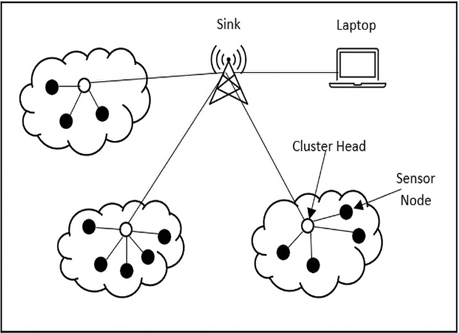
Figure 5.1 – Multi-hop flat routing network diagram
Here, we can see how different clusters of sensor nodes have a cluster head that acts as an intermediate node they forward their information to before having it sent to the data sink that is located at the center of it all.
Location-based routing
Location-based routing is an approach that depends on the location information of nodes within the network to determine the best path for data transmission. The location may be the absolute or relative location of the nodes. If the absolute location is used, the coordinates of the nodes are known – they are obtained through a method such as GPS – and routing is done based on this. If the relative location is used, the nodes measure their relative position to each other, and routing is done based on this.
This type of routing has the advantage of being able to achieve efficient and reliable data transmission through the spatial distribution of the nodes within the network. It would know to transmit data to nearby nodes to reach a destination node that is far away rather than just transmitting to any node, reducing the number of hops that would be required to reach the destination, hence saving energy. It would also help with working with the dynamic nature of WSNs, given that it can adjust to changes in the positioning of nodes or within the wireless communication conditions.
Despite this, some challenges are posed. First, it is difficult to ensure that location information is accurate and up to date, given that there may be areas, such as those within extreme temperatures or urban areas, that may not have acceptable GPS signals, which may make it difficult to achieve this. There may also be the issue of maintaining the location information and ensuring that it is updated based on changes within the location; this can increase the complexity of developing the algorithm for it. It has the potential to provide accuracy within networks but has far more potential for error compared to the other two routing approaches that we’ve discussed.
Choosing between routing approaches can be difficult when minimal information is known about the environment. This is why it is imperative to understand the layout and the dynamics of your IoT network. Will there be many additions and removals of nodes? Will there be bad GPS signals that may cause issues with determining location-based data later? This all needs to be considered because although many of the routing approaches create much promise, it all comes down to how you can pick the optimal algorithm for your use case, and how you can minimize the amount of complexity and errors that may result from your choice.